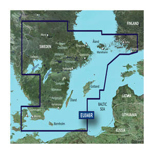
Garmin BlueChart® g3 HXEU046R is an advanced digital marine chart on microSD™/SD™, which provides detailed and reliable chart coverage of Southeast Sweden. The chart is ideal for both coastal cruising and longer trips in the Baltic Sea area, where precise navigation, clear depth information, and safe route planning are essential.
The marine chart combines Garmin and Navionics® chart data and delivers high clarity with updated information on coastlines, depths, harbors, lighthouses, and navigation marks. With Auto Guidance™, you can plan suggested routes based on your boat's desired draft and overhead clearance, while depth range shading makes it easy to identify shallow areas that should be avoided.
The detailed 30 cm contours provide a more accurate representation of the bottom structure and improve both navigation and fishing. Via the ActiveCaptain® app, you can also download NOAA raster charts (where available), which provide paper chart-like views directly on your compatible Garmin chartplotter.
Key features
-
Digital marine chart for Garmin chartplotters
-
Coverage of Southeast Sweden
-
Integrated Garmin and Navionics® chart data
-
Auto Guidance™ route planning
-
Shading of up to 10 depth ranges
-
30 cm contours for a high level of detail
-
Supports ActiveCaptain® features