
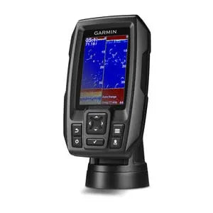


Description
Garmin STRIKER™ 4, with dual beam transducer
3.5-inch CHIRP fishfinder with GPS
- 3.5-inch high-contrast color display
- Internal high-sensitivity GPS
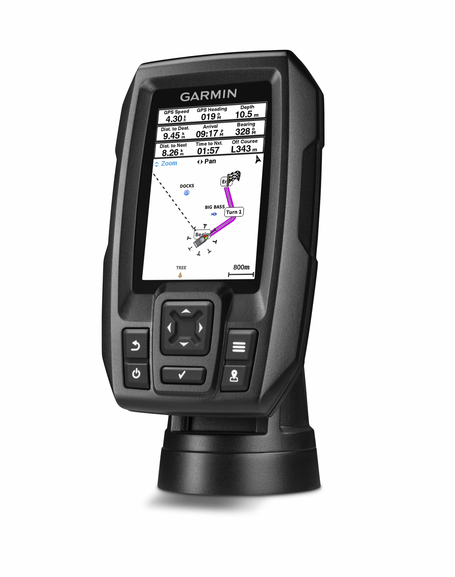
- Find fish: mark and return to your hotspots and docks
- Convenient keyboard operation
- CHIRP (77/200 kHz) sonar transducer; transmit power (200 W RMS)/(1,600 W peak-to-peak)
- Upgrade to high-performance CHIRP with a GT8 or GT15 transducer (sold separately)
With the STRIKER 4 fishfinder, finding fish is easier than ever. Mark and return to your hotspots and docks, and share your favorite waypoints and routes with other STRIKER and echoMAP™ combo units. Smooth Scaling™ graphics provide consistent images as you switch between depth ranges. Sonar history rewind lets you scroll back through sonar images to mark waypoints you may have missed.
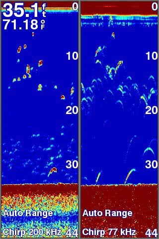
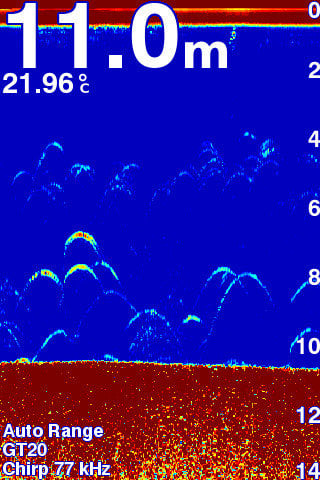
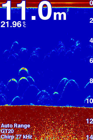
Experience the clarity of CHIRP
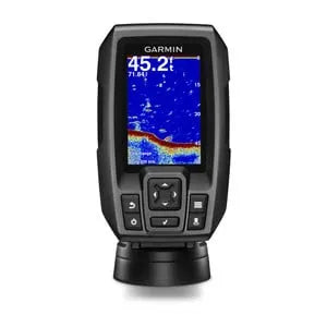
STRIKER 4 includes a Garmin CHIRP (77/200 kHz) transducer that provides visibly greater clarity and more detail when viewing fish and structure than traditional 77/200 kHz transducers.
Instead of sending just one single frequency, CHIRP transmits a continuous spectrum of frequencies from low to high and then interprets the frequencies individually as they return. Because the frequencies provide far more information, CHIRP sonar technology can create sharp fish arches with greater target separation.
You can also upgrade to high-performance Garmin CHIRP technology, which delivers crystal-clear sonar images with even more remarkable target separation from shallow water to deep depths. For better fishing, bottom contours are more visible, even at higher speeds, and signal noise can be suppressed at greater depths to provide a more up-to-date interpretation of what lies beneath the surface.
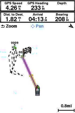
Mark locations with high-sensitivity GPS
Unlike regular fishfinders, STRIKER fishfinders have internal, high-sensitivity GPS that can find your location quickly and accurately, then maintain your GPS position anywhere on the lake. More importantly, they allow you to mark places where the fish are biting so you can return to them later. You can also mark jetties and other locations on the lake. Simply follow the route created on the screen to return to the spots whenever you want.
Navigate easily with Waypoint maps
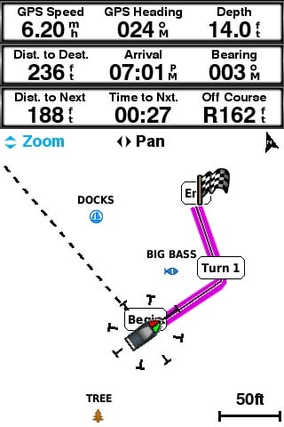
Because the STRIKER fishfinder series has high-sensitivity GPS, you can see your position relative to waypoints you’ve marked. Use the waypoint map to easily see, mark, and navigate to locations like tree stumps, tree stumps, and bridges. It’s also a great tool for finding your way back to the boat ramp.
See your speed on the screen
You can quickly and easily see your boat speed on the STRIKER fishfinder screen. It’s a great tool for making sure you’re going at the right speed for the spinner you’re using and for specific species of fish. The device also allows you to check if you’re going at the right speed in wake control areas.
Fish vertically with built-in sinker
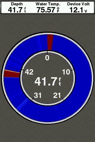
STRIKER gives you both a fishfinder and a sinker in one unit. When you’re fishing stationary, like ice fishing or jigging for trout, the built-in sinker shows you the bottom, whether it’s solid or muddy, the jig or bait with the sinker, and the depth of the fish as they swim into the sonar beam. You can even see how high your jig is lifting and sinking, and whether the fish are moving toward or away from it.
Take your fishfinder with you anywhere
A portable kit is available to protect and transport your STRIKER GPS fishfinder, perfect for kayaking, canoeing or ice fishing. The kit also includes a sealed, rechargeable battery with charger, built-in transducer cable routing and storage, and transducer mount and float.
Appearance and performance
| Display size, WxH | 49 x 73 cm; 87 mm (3.5") diagonal |
| Power supply | 10 to 20 Vdc |
| Display resolution, WxH | 480 x 320 pixels |
| GPS | Yes |
| Physical size (WxHxD) | 9.1 x 15.0 x 4.1 cm |
| Receiver |
Traditional: 50/77/200 kHz |
| Water classification | IPX7 |
| Weight | 230g |
| Mounting options | flush, tilt/swivel |
| Display type | HVGA colors |
Maps and navigation
| Waypoints/favorites/positions | 5000 |
| Routes | 100 |
Features
| Number of legs | 20 feet |
| Transmission power | 200W (RMS) |
| NMEA 0183 compatible | No |
| Has built-in receiver | Yes |
| USB ports | No |
| AutoGain technology (minimizes clutter, maximizes target) | Yes |
| SideVü | No |
| Additional |
|
| LakeVu g3 Ultra | No |
| Water temperature sensor included | Yes |
| Compatible with NMEA 2000® | No |
| GLONASS | No |
| Track points | 50,000 |
| Panoptix™ sonar | No |
| A-scope (real-time display of fish passing through transducer beam) | Yes |
| Adjustable depth line (measures depth for underwater objects) | Yes |
| LakeVü g3 | No |
| Typical power consumption | 0.23 A |
| Supports WAAS | Yes |
| Max power consumption | 1.0 A |
| Auto guidance | No |
| BlueChart g3 | No |
| Standard mapping | No |
| LakeVü (country) | No |
| Fish symbol ID (helps identify fishing targets) | Yes |
| Showing sonar | Yes |
| Log and graph of water temperature | Yes |
| ANT+™ (connection) | No |
| BNC port for external antenna | No |
| BlueChart g3 Vision | No |
| Garmin Wi-Fi® network (local connection) | No |
| Supplementary button operation | Button operator |
| Shading in depth range | Yes |
| Garmin Quickdraw Contours | No |
| Bluetooth® calling | No |
| Miscellaneous |
*Depth capacity depends on water salinity, bottom type and other water conditions. |
| Split screen zoom | Yes |
| Raster map support | No |
| 4-pin transducer ports | 1 |
| ClearVü | No |
| Running tracks | 50 |
| Galileo | No |
| LiveScope | No |
| Bottom lock (shows response from the bottom) | Yes |
| Supported frequencies |
Traditional: 50/77/200 kHz CHIRP (mid and high) |
| Tide tables | No |
| Power consumption | 2.8 |
| BlueChart® (coastal) | No |
| Traditional sonar (dual frequency/beam) | Built-in |
In the box:
- STRIKE 4
- Dual beam transducer
- Mounting brackets for transom and trolling motor
- Tilt/swivel mounting bracket
- Power cable
- Documentation
Kontakformular
Ofte købt sammen med