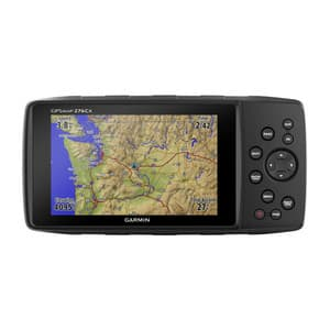
Description
The legendary off-road navigator is back
Developed from the versatile GPSMAP 276C - same amazing customization options
Adds more sensors - with GPS+GLONASS, altimeter and 3D compass
Large 5" WVGA display that is readable in sunlight
Optional advanced navigation - nüvi navigation, TTS voice guidance, Curvy Roads, etc.
Fully connected via Bluetooth®, ANT+® and WiFi® - so you can stay connected
Multiple map options available - including support for BlueChart® g3 and TOPO maps
At a Glance
If you want to experience Garmin navigation at its best, the GPSMAP 276Cx is perfect for you. This navigator provides precise navigation off-road or on the water, no matter where you take it. The new 276Cx adds a number of advanced navigation features without limiting the original 276 experience. With a large 5" display, improved sensors such as GPS+GLONASS, altimeter and 3-axis compass, extensive marine and outdoor features and mapping support, the GPSMAP 276Cx is a strong successor to this legendary product line.
The true 276 experience
The new GPSMAP 276Cx is a development of the legendary GPSMAP 276C, which was known as the most versatile and powerful outdoor navigator Garmin has ever built. To ensure the true 276 experience, Garmin has kept most of the user interface unchanged – even the keyboard is exactly the same as its predecessor. Fans of the 276 will appreciate the many customization options they get with the new navigator and will be excited about all the new features that have been added to the classic 276.
Improved sensor technology
The GPSMAP 276Cx gets a comprehensive update in sensor technology. The device features GPS and GLONASS positioning for improved performance in challenging environments. For optimal satellite acquisition in vehicles, an external antenna (not included) can be connected to the built-in MCX connector. For increased awareness of your surroundings, the device now also features a pressure altimeter for consistent altitude readings and a 3-axis electronic compass for accurate heading in all conditions—even when stationary.
User interface optimized for outdoor use
We know how important optimal readability is during navigation, which is why we created the new GPSMAP 276Cx with a large 5" outdoor-readable display with vibrant colors for better mapping visibility. Due to its wide viewing angle, it can be clearly read from a variety of positions. So even when the unit is mounted in a cockpit, the visibility and button-based interface allow for safe operation, even in shaky environments such as on a boat or in an off-road vehicle.
Robust and durable
Built to Garmin's high standards, this device works in almost any condition. The device is highly durable and waterproof to IPX71 thanks to a thoroughly tested rugged mounting system. With over 4 years of experience working with Montana®, we can provide solid mounts for almost any vehicle or vessel out there. To give you even more freedom, we've made the device more flexible when it comes to power - you can either plug the device into your vehicle's or boat's power supply, or you can use the lithium-ion battery pack (up to 17 hours of battery life) or 3 optional AA batteries (up to 9 hours of battery life).
At a Glance
More mapping, more memory
Almost anywhere you go, the GPSMAP 276Cx has a compatible map to show you the way. It comes with a large 8GB of internal memory with a preloaded global background map, a recreational map of Europe. It also supports a variety of optional maps, such as BlueChart® g3 marine charts, Garmin TOPO and TOPO PRO maps, City Navigator® NT and Garmin Customs Maps. A microSD™ slot lets you expand the memory even further to load additional mapping.
More navigation
Along with relevant mapping, the GPSMAP 276Cx offers additional navigation features such as the familiar nüvi™ mode for road navigation or Curvy Roads route planning for motorcyclists, which highlights smaller roads that are more fun to ride. When used with TOPO PRO maps, the device can choose from a variety of recreational route planning options that select appropriate road types for each activity or vehicle. And for users who prefer navigation on lanes and trails, the new 276Cx also offers advanced trail navigation.
Improved connected features
The new GPSMAP 276Cx also comes with a range of advanced connected features. You can connect your 276Cx via a Bluetooth headset to get TTS guidance on your helmet. Or, when connected to a smartphone2, you can receive Active Weather3, which delivers weather forecasts and animated Weather Radar views on the map screen, smart notifications such as emails, texts or social media updates, or LiveTrack, which lets you share your exact location with family and friends. The device can also wirelessly connect to external sensors via ANT+, such as tempe™ for external temperature readings, or you can connect to WiFi for over-the-air updates and Garmin Connect™ database syncs.
1See Water resistance rating.
2Paired with a compatible phone.
3Active Weather is available in the UK, Ireland, Portugal, Spain, France, Germany, Belgium, Netherlands, Luxembourg, Switzerland, Denmark, Norway, Sweden, Finland, Austria and Slovenia with partial coverage of Northern Italy.
Wi-Fi® is a registered trademark of the Wi-Fi Alliance. The Bluetooth word mark and logos are registered trademarks owned by Bluetooth SIG, Inc. and any use of such marks by Garmin is under license.

