
Description
First-class coastal charts
Industry-leading coverage, clarity and detail with up-to-date coastal charts integrating Garmin and Navionics® content
Auto Guidance1 technology quickly calculates a suggested route with the desired depth and clearance
With depth range shading for up to 10 depth ranges, you can quickly see the target depth
30 cm depth curves provide a more accurate representation of bottom structure on the improved fishing chart
To provide a clear view of shallow water that should be avoided, you can shade custom minimum depths
Experience unparalleled coverage and stunning detail when you're on the water. BlueChart g3 Vision coastal maps provide the industry's best coverage, clarity and detail with integrated Garmin and Navionics content.
Autoguide
Whether you're a fisherman or a sailor, you can benefit from Garmin's automatic route calculation, which generates a route suggestion with safe depth1 for your boat.
Autoguide
Shading in depth range
To provide a clear view of shallow water that should be avoided, you can shade custom minimum depths.
Shading in depth range
Shallow water shading
To provide a clear view of shallow water that should be avoided, the Shallow Water Shading feature provides shadow coverage at a user-defined depth.
Shallow water shading
Detailed depth curves
BlueChart g3 Vision charts feature depth contours at 12-inch intervals, providing a more accurate representation of bottom structure on the enhanced fishing chart.
Detailed depth curves
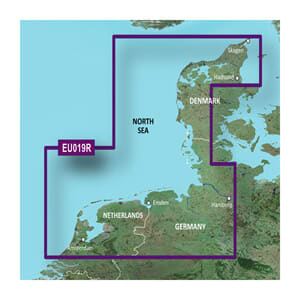
Satellite images
Satellite imagery with navigation map overlays gives you a realistic view of your surroundings. It's our most realistic map display in a plotter – a great help when calling at foreign ports, for example.
Satellite images
FishEye view
This underwater perspective shows a 3D rendering of the bottom and contours seen from below the waterline. Graphical presentation of sonar data is possible.
FishEye view
MarinerEye view
This view provides a 3D image of the immediate area, both above and below sea level.
MarinerEye view
Aerial photos
Crystal clear aerial photos show many marinas, ports, and marinas in high detail, and it is ideal when entering foreign ports.
Aerial photos
1 Auto Guidance is for planning purposes only and is not a substitute for safe navigation.
Categories
Ofte købt sammen med